

4.9 degree earthquake hits El Hierro and is felt on La Palma and Tenerife
For all the latest updates on this news story please follow us on Twitter we’re @canariesnews or ‘Like’ our Facebook page.
Update 3rd April 2013 @ 09:30 – The island of El Hierro has been hit by two earthquakes above 4 degrees (Richter) this morning, according to the National Geographic Institute (IGN). There has been an earthquake of 4.2 degrees at 03:41 hours and another of 4.5 degrees before this one at 02:45.
Update 2nd April 2013 @ 19:30 – According to data received, the earthquakes are approaching the coast of the island of El Hierro. The current increase in earthquakes are also showing the same signs of those that occurred before the volcanic eruption last year. The report also shows that the island has been deformed by 11 centimetres since the last process started in March 2013.
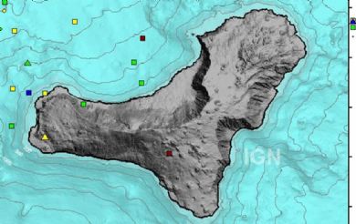
%CODE06%
Update 31st March 2013 @ 19:30 – The IGN has now confirmed that this mornings earthquake at 10:59:54 WAS recorded at 4.9 degrees on the Richter scale. On its website it has initially reported this quake at 4.9 degrees but then corrected the data saying that it had only been 4.6 degrees. It has now confirmed that its initial assessment was correct and has changed the data back to 4.9 degrees. This makes todays earthquake the largest recorded in the whole process which began in 2011.
Video of landslides on the island of El Hierro after earthquake:
Update 31st March 2013 @ 16:30 – An earthquake which was wrongly reported as 4.9 degrees on the Richter scale which hit the island of El Hierro this morning was corrected by the IGN as being a 4.6 degree quake. This earthquake, which took place at 10:59:54 this morning (local time), had its epicenter in the sea to the west of the town of Frontera at the point where the greatest concentration of earthquakes in recent days has taken place. The quake, which was felt on the island of La Palma, was at a depth of 20 km and occurred just an hour after another earthquake measuring 4.5 degrees. The IGN performs a continuous review of the data published on its websites which is why at first it had indicated that there had been an earthquake of magnitude 4.9 and subsequently updated the information and said that it had been 4.6 degrees. The president of the Cabildo of El Hierro, Alpidio Armas said that the earthquake has caused some landslides on the road to Sabinosa in La Dehesa.
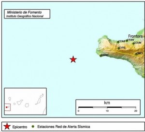
Update 30th March 2013 @ 10:30 – The IGN (Nationa Geographic Institute) recorded last night 51 small earthquakes, one of which was been felt by the population on the island of El Hierro. The most powerful of these earthquakes occurred at 00:30 this morning at a depth of 19 kilometers, with a magnitude of 4.3 on the Richter scale. The epicenter of these earthquakes is in the sea, as in previous days, west of the town of Frontera, with depth varying between 14 and 25 kilometers. Of the 51 earthquakes recorded between midnight and 08.11 this morning, nine exceeded magnitude 3, thirty ranged between 2 and 3, and two did not reach 2 degrees Richter. In total yesterday, Friday 29th March, there were 184 earthquakes, a hundred of them with a magnitude greater than 3 degrees Richter, including one of 4.7, the highest in the earthquake/volcanic process which started in 2011. The direction of the Civil Protection Plan for Volcanic Risk in the Canary Islands (PEVOLCA) has kept the ‘yellow light’ of seismic risk in place on the island.
%CODE13%
Update 29th March 2013 @ 17:30 – There has been an earthquake on the island of El Hierro registering 4.7 degrees on the Richter scale that has been felt by the population of the islands of El Hierro, La Palma and in places of Tenerife. It happened today (Friday) at 17:00 (local time) and was at a depth of 20km at latitude 27,7 y longitude -18,3.
Update 28th March 2013 @ 09:00 – The Civil Protection Plan for Volcanic Risk in the Canary Islands (Pevolca) has changed the ‘traffic light’ system for warnings of seismic activity from green to yellow on the island El Hierro and has closed roads on the island which may be exposed to landslides due to quakes or tremors. In a statement released last night, Pevolca announced the change of the warning state and road closures of the HI-500 and HI-400 , at El Tomillar. According to the Cabildo of El Hierro, the Los Roquillos tunnel has been closed at Frontera and closed the road for traffic between the HI-50’s Cruce de La Tabla and Sabinosa and access to the La Madera beach. These measures were taken after the earthquakes recorded yesterday afternoon reached a magnitude of 4.6 degrees on the Richter scale, the highest in the whole process of the 2011-2012 eruption and seismic spikes that have taken place since. The Emergency Coordination Centre Control Room (CECOES-112) received several calls regarding some landslides in the area of Guinea, as explained in a press release, which noted that “there was no warnings related to infrastructure damage or injury to people. “. The quake was recorded at 15:07 hours yesterday afternoon, with an epicenter in the sea to the west of La Frontera.
%CODE13%
Update 27th March 2013 @ 11:00 – During the night El Hierro has been hit by another wave of earthquakes, 49 in total, none of them felt by the population of the island, according to data collected by the National Geographic Institute (IGN). The most powerful of these small earthquakes occurred at 05:51 this morning and had a magnitude of 3.3 degrees on the Richter scale. Just three minutes later, there was another 3.2 degree quake at almost at the same coordinates. As in previous days, the epicenter of these earthquakes is in the sea, to the west of the town of Frontera, at a depth of between 15 and 16 kilometers deep. Of the 49 earthquakes recorded since midnight, three exceeded a magnitude of 3 degrees, 44 ranged between 2 and 3 degrees and two did not reach 2 degrees (Richter). Yesterday there were 200 earthquakes, 15 of them with magnitude greater than 3 degrees.
%CODE13%
Update 26th March 2013 @ 16:00 – The Civil Protection Plan for Volcanic Risk for the Canary Islands (Pevolca), has decided to maintain the ‘traffic light’ system which determines the danger to the population of the island of El Hierro at it’s ‘GREEN’ status because, in their opinion, the current seismic activities do ‘not pose a risk to the population’. Despite this, scientists have said that their is a ‘75% chance’ of the island experiencing an earthquake of up to 4.3 degrees (Richter), but discard any risk to the population because the phenomenon is currently located 10 km. from the coast. The Canary Islands Government is meeting today in Santa Cruz de Tenerife to analyse the seismic activity data from the island.
%CODE13%
Update 26th March 2013 @ 09:00 – The National Geographic Institute (IGN) has recorded (up until yesterday afternoon) 106 earthquakes, one of which registered 4.1 degrees magnitude on the Richter scale, the largest since the seismic activity restarted on 15th March. This earthquake was recorded at 14:41 hours in the sea to the west of the town of Frontera, at a depth of 16 km. This is the same locations and at the same depth than the one that was recorded at 5:57 pm yesterday with a magnitude of 4 degrees. Of the total number of earthquakes recorded yesterday, 21 had a magnitude greater than 3 degrees on the Richter scale, 70 had a magnitude of 2-3 degrees and 15 under 2 degrees.
%CODE13%
Original Story:
The quake, which was felt by the population of the island, occurred at 05:57 this morning, with the epicenter in the sea to the West of Frontera at a depth of 16km.
Since midnight, the National Geographic Institute (IGN) has recorded 56 earthquakes on the island of El Hierro, 17 of them with magnitude greater than 3 degrees on the Richter scale, another 33 between 2 and 3 degrees and six below 2 degrees.
This past weekend, the island was hit by 329 earthquakes, 170 on Saturday and 159 on Sunday, 22 of which exceeded 3 degrees on the Richter scale. These two days have recorded the most quakes since the re-activation of this new seismic phase.
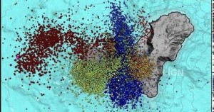
Image of the latest activity of El Hierro earthquakes

